Saturday, July 31, 2010

Day 27 – Broadview to Elkhorn, MB (T.D. 114km; S.T.: 5h44min)

Woke up, early enough, to an already-hot day. Luckily, we don’t seem to feel the heat quite so badly when we’re riding. Not sure what the temperatures have been like, but I’m guessing somewhere in the low 30s. We had only a vague sense today as to how far from the Manitoba border we were (turns out we were almost exactly 100km away – how ‘bout that?), but we knew we wanted to get there, and a bit beyond. Yesterday’s headwind had vanished in the heat, and we made good time to Whitewood, where we picked up some Subway sandwiches to take with us. Made it all the way to Moosomin before we stopped to eat them, and there treated ourselves to a peanut buster parfait at the DQ. Fast food. You are what you eat. (How unhealthy are we?)

In Moosomin, the skies started to look a bit ominous, which lent an air of urgency to our run for the border. Fortunately, the stormclouds never caught up with us, which gave Saskatchewan a perfect “no-rain” record. Way to go Saskatchewan. (This, in a summer of record rain for the province.)

We stopped for the requisite photos in front of the “Welcome to Manitoba” sign (Batty, this one's for you!), and then poked our heads into the Welcome centre. The staff there were the most helpful bunch of people we have yet encountered in a tourist info place. Moreover, they were surprisingly pro-cyclist, and even had a special guestbook for those who had brought themselves there on two wheels. (We found Dan and Ally’s signature a few pages back.) They helped us find and reserve a campsite in Elkhorn, about 14 kilometres away, and to our amazement, they even stopped in later to make sure we had gotten there alright. With folks like this running your Welcome Centres, it occurred to us that Manitoba might do well to adopt a slogan emblematic of such friendliness. Something like: “Manitoba: So Friendly” or “Manitoba: A Friendly Province”. When we finish this bike trip, we’re going to write a couple letters to the premier and suggest it.
The friendliness didn’t end at the tourist booth either. When we got to the campsite, we made friends with fellow travellers Edward and Juanita, who invited us to have dinner with them in their camper van. Edward and Juanita are siblings who are on an epic road-trip all over the Western half of the continent. They’ve been on the road 6 weeks and show no signs of slowing down. Both of them are retirees from jobs that hold great significance for travellers like us: Edward was an asphalt mixer, while Juanita worked in a factory line making the sort of handsoap you find in campground bathrooms (if you’re lucky enough to be at a campground that has a bathroom. The one in Elkhorn did). Anyway, they were a great pair, and we were very pleased to eat their food and spend some time with them.


Stats:

Av. Spd.: 19.8km/h
Mx. Spd.: 29.0km/h
Provincial borders crossed: This makes 3
Hours lost to time zone differences: Add another to the pile
Ability to sleep through train whistles: Not yet acquired.
Temptation to sell bikes and purchase camper van: Present
Candies taken from strangers: Some
Evidence that human kindness still exists: Yes

Day 26 – Indian Head to Broadview (T.D.: 88.5km; S.T.: 5h59min)

Bellies full of instant oatmeal, we began a slow crawl out of Indian Head and towards the Manitoba border. A strong headwind today meant that we weren’t about to break any speed records getting there. (As a matter of fact, we did set a new speed record today. Unfortunately, it was for slowest average speed – beating out our day slogging it up to the top of Roger’s Pass even). Three hours on the road brought us to Wollesley, a mere 30 kilometres from our campground, where we bailed out, dog-tired, to have lunch, rest, and see if the wind would change directions. Wollesley is a self-proclaimed “Town Around A Lake,” which, of course, amazed and delighted us. The man at the visitor info centre was quite adamant that we go have a look at the lake, and so we did. It was nice.
Most importantly, during our sojourn there, the winds died down a bit, which made for slightly speedier progress getting to Grenfell, where we stopped for another snack. To our great dismay, however, while we enjoyed our snack of dried fruit and cashews (how healthy are we?), the winds picked up again. We made it another 20km to Broadview, where we gave up, beaten by the wind. On a lighter note, Broadview is the home of Sergeant Bill, Canada’s oldest mascot. Sergeant Bill is a goat – was a goat. He’s dead now. (Can you tell it was a slow day today?).


To cap off our misfortune, we ordered a pizza at Kaycee’s Roadhouse, and after laboriously explaining to the waitress that we wanted one side with pepperoni and veggies (for me) and one side with just veggies (for Caroline), she brought us one with pepperoni and veggies on one side and just pepperoni on the other. Caroline enjoyed the extra protein. It had been a hard day, after all.

Stats:


Av. Spd.: 14.7km/h (a fine average speed – if we were RUNNING across the country)
Mx. Spd.: 23.7km/h (Such great heights! This came as we rolled into Broadview at the very end of the day, off a lightly inclined overpass).

Number of other campers at the campsite: 0

Number of bathrooms at the campsite: 0 (you can’t really count the little-bit-too-full-for-my-liking port-a-potty – or maybe I’m just high-maintenance)

Number of hayfields that could substitute for a bathroom if absolutely necessary: 1

Number of spectacular sunsets that redeemed the day: 0 (It wasn’t a very good day.

…Actually, I’m lying, it was pretty decent. I’m just being dramatic to make things more interesting for you.)

Day 25 – Regina to Indian Head via Qu’Appelle Valley (T.D.: 131km; S.T.: 7h22min)

Yikes, that last entry was not as stimulating as it could have been. It was late. We were tired (Caroline had to finish it off for me). It does a disservice to our wonderful hosts in Regina, Okie and Gisella (I hope you got at least some sense of how wonderful they were). We had a great time with them, eating and talking about travelling adventures. This continued over a delicious breakfast on Day 25 and we were sad to say goodbye to these newfound friends.
From Okie and Gisella’s, we took a cut-off/bypass highway out of Regina, and it was 30 kilometres before we met up with the TransCanada again. Here, we stopped to consider our options. Part of the reason why we had been up late the night before is that we were taking a second look at our planned route, which was to travel northeast through the Qu’Appelle Valley, make a pilgrimage to Melville (for reasons I’ll explain in due course), and then take Highway 16 (the Yellowhead) down through Manitoba to Winnipeg. We had chosen this route over the TCH because Manitoba is infamous for having terrible highway shoulders, including on the TransCanada – and a number of cyclists have been killed because of it. The Yellowhead would be a relatively quieter highway in comparison, so “white-lining it” (that’s what you call it when you have to ride on the white line ‘cause there’s no shoulder) would be proportionately less nerve-racking for us. After a bit more research at Okie and Gisella’s, however, we determined that neither route was ideal, and that we may have to improvise our way through on secondary highways, popping onto the major arteries for as long as we could stand it, and then ducking out when there was a suitable alternative.

As we sat in the shade of a Shell service station, we pondered these options and decided to send a text message to Dan and Ally. Remember them? They’re the father and daughter cyclist pair who we met back somewhere around Roger’s Pass. They, to the best of our knowledge, had not detoured through Drumheller, or taken an extravagant double rest day in Medicine Hat, and were therefore likely to be a few days ahead of us, and already well into Manitoba. We heard back very promptly. Turns out they were in Brandon, MB, and had stayed on the #1 the whole way. It also turns out that Manitoba has finally decided to get on the ball and pave the TransCanada’s shoulders (this is a brand-new thing for Manitoba – as recent as last summer, the TCH’s shoulders remained unpaved). Problem solved. We would take the TCH. Thank you, magic of texting.

This left us with the decision of whether or not to detour through the Qu’Appelle Valley – a region of Saskatchewan that’s renowned for it’s beauty and atypical (for Saskatchewan) landscape – and continue with our planned pilgrimage to Melville. We decided to go with the former, but lopped off the latter from our itinerary. The Melville pilgrimage was a silly sort of thing anyway. There is a small (some would say insignficant) connection with the town and my favourite Canadian band, the Rheostatics, and I had been pleased to find that it was not too far out of the way on our original route. With the change in plans, however, it would be too much for too little, so as compensation, I pulled out my iPod and listened to their album Melville as we headed up highway 10 towards the Qu’Appelle river. The river valley is certainly beautiful, and certainly atypical of the Saskatchewan landscape norm. It’s sort of a more lush version of the Red Deer river valley in Alberta, and was a nice escape from the endless farmland we’d been touring through for several days now. The detour meant an extra 60 kilometres, but was well worth it to get off the main highway and see a bit more of the province. Caroline had a dipped cone and I a giant cinnamon roll in Fort Qu’Appelle, which made the side trip even more worthwhile. It was late by the time we got back to the TCH, and we were ready for a big meal (courtesy of Esso) and a good sleep (courtesy of the Indian Head KOA Campground).


Stats:

Av. Spd.: 17.7km/h (Rough shoulders and lots of rolling hills leading up to and along the river valley slowed us down. Also a bit of a headwind as we headed south towards Indian Head. Them’s my excuses)
Mx. Spd.: 43.5km/h

Strangest insect: A weird sort of amber-coloured dragonfly that was a common sight through the Valley. It looked like a sliver of dark glass, like a beer bottle shard, only with wings.)

Best guess as to how long it takes to cycle through Ontario: A young guy at the campground. He ventured (quite overwhelmed, even, by the possibility) that it would take “4 or 5 days”. Having looked into it ourselves, we estimate it will take about 29 or 30.

Most unfortunate town name etymology: Indian Head’s – apparently this, the highest point of land in the region, was where many of the Assiniboine people who lived there went to die during an outbreak of smallpox caused by the arrival of European fur-traders sometime in the 1800s (it was customary, I guess, to travel to the highest point of land when it was your time to go).

Biggest disappointment (besides the exclusion of Melville from the itinerary): Not seeing the giant “Indian head” that is a town landmark. (We couldn’t find it. Can’t be that giant.)

Tuesday, July 27, 2010

Day 24 – Moose Jaw to Regina (T.D.: 82km; S.T.: 4h02min)

Up early again today – I think this will be the trend from here on out. Leaving early means you have far more time to explore, take breaks, etc., and the morning weather tends to be far lovelier to bike in. We were having breakfast at a Tim Horton’s in Moose Jaw as the sun was rising, and on the road sometime around 7:20am). There was a huge tailwind today, and not a lot of distance to cover to get to Regina, so it was no time at all before we were within the city limits. Our average speed for the first 65km was 23.5km/h, which means we were taking our picture at the “Welcome to Regina” sign well before noon. From there, we took our time (well, we were forced to take our time – you turn north to get to the city centre, which meant we all of a sudden had a very strong cross-wind slowing us down and pushing us around) exploring the city, and had lunch in a big park. We like the look of Regina – it’s got that polished capital-city sort of look, but my bet is there’s a fair bit going on here under that veneer of respectability. At the very least, there are a lot of hot-dog stands. Not sure what that tells you.

We’re staying the night here at the home of Okie and Gisella, who are connected to Caroline in a distant, roundabout sort of way that probably isn’t worth explaining. I can vouch for their warmth and generosity though, as they’ve made us feel very comfortable so far, and pretty much given us the run of the place as we do our usual routine of showering, laundry-ing, and (most importantly) blogging. For dinner they fed us a meal that was almost entirely grown themselves (except for the food that had legs or fins).

We had planned to take a rest day here, but we arrived so early that today sort of feels like a rest day anyway. Onward to the Qu’appelle valley tomorrow!

Wee.

Stats:

Av. Speed: 20.3km/h (It dropped as soon as we had to move in any other direction but east, coming into Regina)

Max. Speed: 46.1 km/h

Number of witty statistics for this entry: Zero (sorry, bedtime!)

Day 23 - Chaplin to Moose Jaw (T.D.: 90km; S.T.: 5h49min)

Woke up, dew-covered, at 5am this morning in order to get an early start and beat this prairie heat. We were rewarded for our ambitions with the prize of thick fog and a fierce headwind. The fog lifted before too long, but unfortunately, the headwind only intensified. This was our first day dealing with a headwind for any great length of time, and it was an interesting experience. It's kind of like you're always going uphill, which is a bad thing, but you stay nice and cool even though you're working so hard (because of the constant wind), which is a good thing. All in all, the day went by quite quickly even though our progress was slow and our saddle time long. I think the early start probably helped in that regard. And we did get most of our riding done before the heat really set in.

Our first few hours were spent looking for signs that might indicate when we would next cross paths with a grocery store or restaurant of some kind. For some reason, we had let our food supply dip dangerously low, and we were down to our last two dried apricots before we hit kilometer 20. After this, we would be forced to subsist on spoonfuls of peanut butter. Smooth peanut butter, even. Luckily, we found some fresh-baked cinnamons in the town of Mortlach which saved the day. Thank you Mortlach! (Next time, we’ll pack sunflower seeds – thanks for the tip, Anna!)


Mortlatch also provided the meeting grounds for an encounter with a young man name Ryo. Ryo is from Japan, but is cycling across Canada in search of a job, dropping resumes off in every city he passes. Ryo is much faster than us, but as a solo cyclist, we discovered, he is more susceptible to attacks by wild animals(!). We were tipped off to this fact when he asked us, in all seriousness, “So, have you been attacked by many wild animals?” As it turns out, Ryo had, to that point in his journey, come under the claws of at least two hawks, and was chased by a coyote through the Cypress Hills. No bears (or bearcows) yet, however. He had also been caught in a hailstorm somewhere near the summit of the Kootenay Pass.

While Ryo sailed past us for his next wildlife confrontation, we continued to fight the headwind until Moosejaw, where we set up camp for the night at the Prairie Oasis Tourist Complex (it was as lovely as it sounds...), after which we headed downtown to find something to eat. Moose Jaw lays claim to the most all-you-can-eat Chinese-Canadian buffets in the whole world (I am certain that this is a fact), which suited us fine, being a Chinese-Canadian couple after all. We ate all that we could.

Stats:


Av. Spd.: 15.4km/h (the headwind really killed us)


Mx. Spd.: 32.5km/h (this occured on a small hill during the first couple kilometres of the trip - the rest of the time, we didn't go much higher than 18km/h - does anybody care?)


Evidence of a peculiar brand of Saskatchewan humor: A sign that said “Point of Interest: 2km” and then, after two kilometers, a turn-out that had nothing but a big garbage bin on it. Very funny! I worked hard to get to that point of interest.


Contents of our food bag after the dried apricots were eaten: Four or five tablespoons of peanut butter, a couple of those jam things that you get at breakfast restaurants, a small bag of powdered milk, and a handful of drink crystals.


Most surprising non-encounter: Ryo camped in Chaplin the same night we did, but at a different campground, amazingly. Chaplin is REALLY small. Why does it have two campgrounds? His cost 20 bucks, while ours cost 10. Ours had a pool. His didn't even have showers. He chose poorly.

Day 22 - Swift Current to Chaplin (T.D.: 94km; S.T.: 4h37min)

Woke up, mostly dry, beside a very well-watered lawn. Our sleep had been just restful enough, what with the sprinkler system, the It's-Saturday-night-in-Swift-Current! crowd of revelers that appears to haunt Sandy's neighbourhood, and the few well-timed train whistle blasts that pierced through our disembowled-prairie-deer nightmares to punctuate an otherwise good night's sleep. We had a romantic homeless-couple picnic breakfast in Wood Buffalo Park down the street, and filled up our water bottles at the Subway restaurant near the highway (what a life we lead!) before getting the day's ride underway.

Today was notable for a few reasons. One was the amount of hills we had to climb up. This part of Saskatchewan is by no means flat, and one hill had us inching our way along for over 6 kilometres. At the top of this hill, though, we found a lovely tree that gave us some lovely shade in which to enjoy a lovely breeze and a lovely snack. We really liked that tree (trees are hard to come by in this part of the world!).


A second notable feature of the day was the high concentration of ghost towns we discovered along this stretch of road. Perhaps the shops and service stations were closed because it was a Sunday, but one got the feeling in Herbert, Morse, and Chaplin, that the shops and service stations in these places are just never open. The forsaken grain elevators casting lonely shadows over abandoned bowling alleys reminded us of an incredible art exhibit called “Woodrow” that we’ve been privileged to see a couple of times, once at the Halifax art gallery and once at the Rooms in St. John’s. Here’s a website about it: http://www.graemepatterson.com/WoodrowMapFrameSet.htm .


The last of these towns. Chaplin, was our destination for the day, and as we neared it, in the blazing July sun, we were shocked to see snow and ice covering the fields beside the highway. Could it be true? Was this just a sun-stroke induced mirage, or had the world gone topsy-turvy, firing off snowstorms in the middle of heatwave?

Nope, nope, and nope. It was salt! Horrible salt! The sort of salt that is carried by the wind until it coats your body and tent, making you and your possessions alarmlingly flavorful. The good news is that Chaplin has a swimming pool (and rather incredibly, the swimming pool was full and operational!), so we enjoyed a good swim that washed off some of our seasoning before we hit the hay (the campground was an old hayfield). We were the only ones in the whole field. Good old Chaplin. It was a strange town.


Stats:


Av. Spd.: 20.4km/h

Mx. Spd.: 47.1km/h


Worst place to go when you need to use the bathroom: Morse! Nothing was open! Actually, one place was open – thank God.


Worst place to have a snowball fight: Chaplin! It's not really snow! It's salt!


Best place to have a salt fight: Chaplin

Most amazing dinner feat: Finishing the two piece farmer's sausage meal at the Chaplin hotel. Who knew a farmer's sausage could be so big?


Stat most likely to be misconstrued distastefully: That last one. I just realized it now. But I'm serious – it was a really big meal! It came with onion rings! Each sausage was the size of a very large banana, peel on. The waitress had made some hand gestures to give me an indication of the size, but she was way off. It was double what she’d indicated. Caroline had fish and chips (I know, Alex...never eat fish when you’re 2000 km from an ocean – but sometimes there isn’t much to choose from on these menus. Hence the farmer’s sausage debacle.)

Day 21 – Maple Creek to Swift Current (T.D.: 131km; S.T.: 6h10min)

After we found our way out of the enormous bed in Loree's guestroom, we made our way to the kitchen, where our host was waiting with some delicious homemade porridge to help us get the day started right. A couple of french twists later (Loree also braided Caroline's hair – I have no idea if they were french twists or not), we loaded the bikes into Loree's truck to get through a few miles of gravelly dirt roads and back to the highway. Since we hadn't actually seen the town of Maple Creek, Loree also gave us a little tour of the place before dropping us off. We had to do a bit of convincing in order to persuade her to not drive us any further than the highway junction, as she would have happily given us a lift all the way to Swift Current if we'd let her.

It was good to get back on the bikes though, and the thought of a 130km day ahead of us eased any guilt we had for having cheated our way out of 15km the day before. Since it was ten o'clock before we started pedalling, it wasn't long before the mid-day heat arrived, which made our penance all the greater. Purgatorial though it might sound, we had heavenly stops along the way in Piapot, Tompkins, and Gull Lake, during which we refreshed ourselves with the hearty lunch Loree had packed for us (what a saint she is!). Today was also a day where the road ran closely alongside the railway, a bonus for people like me, who derive great joy from the sight of a passing train. I'm not sure if Caroline gets the same thrill. She did, however, give one engineer a big wave, to which he responded with a blast of the train whistle. What fun! Nothing stirs the spirits like this! The last time that happened was somewhere outside of Abbotsford. I really like trains.

Trains aside, we were pretty exhausted by the time we reached Swift Current. Loree had arranged for us to tent in the backyard of one Sandy Larsen, former Mayor of S.C.. Sandy was out at her farm for the weekend, so we let ourselves in (well, not really IN – more like around) and set our tent up under her second-story back porch. This way, we wouldn't mess up her lawn, and we could sleep without the tent-fly. We discovered that this had been a most fortuitous course of action around midnight, when the sprinkler system in the backlawn came on, and proceeded to douse the grounds about every hour. Most fortuitous indeed.


Stats:


Av. Spd.: 21.3km/h

Mx. Spd.: 45.2km/h

Greenest lawn award: Sandy Larsen, of Swift Current.

Most horrifying roadkill: A deer. Or, more accurately: half a deer. The other half was about a kilometer down the road. Perhaps our dreams have been too sweet of late, and we needed a nightmare-inducing sight like this to balance things out.

Best way to feel like a real-life hobo: Brush your teeth in the bathroom at a Smitty's restaurant. Bonus hobo-points if you didn’t actually buy a meal there (we did – no bonus points for us).

Best way to feel like a real king: Eat the chocolate suicide cake at a Smitty's restaurant.


Friday, July 23, 2010

Day 21 - Medicine Hat to Maple Creek (T.D.: 82.5km; S.T.: 3h48min)

Surprise, surprise, we're actually posting a current update! We arrived in Maple Creek this afternoon, and are staying with Loree Redick, a friend of my co-worker's mother (how tenuous a connection is that?).
Loree is a farmer here in Maple Creek, and is quite amazed as to how or why we would want to bike across this country. She has been an incredible host, though, especially considering that we are complete strangers. She even surprised us by showing up in her truck about 16km
from town - and wouldn't take no for an answer when she offered us a lift the rest of the way to her farm.
We felt a bit funny taking the ride - when you're riding 6400km across Canada, you don't want to leave out a 16km section between Medicine Hat and Maple Creek -- but it did force us to reflect on why exactly we're doing this trip. Is it to cover every kilometre self-propelled, unaided by motors and engines? Or is it to get to know your home country a bit more intimately than you might driving through it or flying over it? We settled on the latter, and as Loree drove us, off-road, through her vast crop fields and cow pastures (we had to find the llamas that keep
the coyotes at bay), we figured we were getting a glimpse of Saskatchewan that we certainly wouldn't have had on our bikes. Forgot those 15 kilometres (what's 15 kilometres of prairie landscape in a stretch of about 1000 anyhow?)


I should say, though, that up until our little four-wheel fling, the ride was really beautiful. A perfect riding day, with moderate temperatures, captivating scenery through the rolling cowboy-and-indian hills of Cypress County, and the wind at our backs the whole day (note our fastest average speed yet in the stats below). This stretch of road is also where there have been record rainfalls these past few months, which caused part of the TCH to be washed away not too long ago (it's fixed now) and has probably made the countryside about as lush as it ever is likely to be. It was really a lovely ride.


We also hit a couple of milestones today. For one, we entered our third province of the journey as we transitioned from Alberta to Saskatchewan; and for two, we hit the one-quarter mark of the entire trip somewhere around kilometre 1600. As my brother Matt has informed us, that is well past the 1407km it takes to get from the northern-most point of Scotland to the southern-most point of England. Take that, British Isle.

Back at the ranch - or Loree's house - we enjoyed an incredible home-cooked meal - fresh roast beef straight from the fields around us (Caroline even tried a piece) with all the fixings. Loree even made Caroline's favorite dessert - having learned it from reading our blog. She didn't have any butterscotch chips, so she used chocolate. We weren't about to argue.

Hard to beat this Saskatchewan hospitality - we're happy to be here.

Stats:

Av. Spd.: 21.6km/h
Mx. Spd.: 52.3km/h
Cumulative Distance: 1615km
Days since being in a motorized vehicle: 20 - I guess we can set that meter back to zero.
Number of acres on Loree's farm: 3120, approximately (she says it's "medium-sized")
Number of cows: 150
Number of calves: 150

Number of adult bulls: 6
Number of llamas: 9
Number of alpacas: 5
Number of dogs and cats: a handful
Number of eligible bachelors in Maple Creek: none, apparently (Loree says she could use some help in this department)
Number of tractors converted into jungle gyms: 1
Number of awesome electric massaging chairs: 1
Number of servings Pat had at dinner: 3

Number of chocolate marshmellow squares Caroline had: how many squares in a casserole dish?
Number of squared feet that make up our bed: 127 (it's a really big bed)
Number of statistics that have numerical values today: 15 - well, this makes 16.

Thursday, July 22, 2010

Day 20: Rest Day 2 in Medicine Hat

Another long sleep, followed by blog-writing and route-planning for the next leg of the trip. We’re looking forward to Saskatchewan!

I suppose I should address some questions that have popped up. First off, we’re just so pleased that people are actually reading this blog and even more pleased that some of you seem to be enjoying it. It’s great for us to keep track of our travels, so we’re happy that other people can get something out of it as well.

Jen: Caroline usually rides in back, actually. That, as Alex has correctly perceived, is why I am dominating the ground squirrel game. As for the collisions, she ran into me the first time, and on one of her rare turns in the front, I ran into her the second. I’m not used to having anything in front of me! I’m not sure what her excuse was.

Regarding our water intake, I’m not too sure. I’ll keep better track during this next stretch. We have 5 water bottles between us (we had 6, but one exploded back in Golden), and Caroline probably drinks more than me. We often split a Powerade at some point during the day, and then drink water, juice, soda pop, or chocolate milk during meals. Oh, and Caroline is fond of buying one Yop a piece whenever we go to the grocery store. So probably something like 4 or 5 litres a day. I don’t know if that’s a lot or a little. I’m not very hydration-conscious.

Shirley: Our saddle time is indicated in the titles of each blog, beside the daily distance. That’s what S.T. means. Where were you on Day 1?

Kathleen: Congratulations on your bike achievements! Keep up the most excellent work!

Andrea: I was very pleased that my marmot sighting made the classroom rounds! Also, I talked to Loree today, and she seems excited to house us – we arrive in Maple Creek tomorrow! Also, thanks for googling that commemorative plaque! I was dying to know what went down there. Apparently, it was a plane. Ha! Eee. Too soon?

We love reading the comments - so please keep them coming. Talk to you in Regina or something...

Here is an excerpt from the weekly Thursday night bluegrass session that Kelly holds in his shop.

Day 19: Rest Day 1 in Medicine Hat

A beautiful day in old Medicine Hat. Slept for 12 hours. Replaced a bike chain on my bike, with some difficulty, but not too much. Thanks to the Bike Doctor himself, Paul Tettamenti for showing us how back in Vancouver. We also gave our bikes a good wash, so they are nice and shiny now. Did some laundry, some groceries, had a delicious steak dinner (salmon for Caroline) with Kelly and Anne, then Kelly and I played a few tunes together (Kelly is a mean banjo player!). A great rest day.

Day 18 – Emerson Bridge to Medicine Hat (T.D.: 157km!!!; S.T.: 7h41min)


Big day today. We had planned to take two days to cover this stretch of road, but the only camping option between here and the Hat was only 50km away, so we decided to go for it and do it all in one sweep instead. Our first stop was Brooks, where we made use of some Tim Horton’s gift cards to fuel up. When facing a day this long, the two most important things are eating well and often, and getting off the saddle to give your body a break. A bodybreak

(http://www.youtube.com/watch?v=-SHDDA4mi4U&feature=related)!

Stopping at a convenience store on our way out of Brooks, we learned from the lady behind the counter that an “older gentleman” doing a cross-country bike tour had been by earlier in the day. Wayne McInnis, perhaps? We think so.

We arrived at Tillebrook Provincial Park before noon – our scheduled campground for the night – which reaffirmed our decision to carry on and cover the rest of the distance to Medicine Hat in a single day.

Our fiercest obstacle proved to be boredom, with hardly a ground squirrel or gopher to be found. We made lots of stops en route, mostly to eat the delicious snacks we’d packed (blueberry cheesecake, apple strudels, etc.) and give our aching bottoms a chance to recover.

We were happy to see signs of civilization as we approached RedCliff, which is a small municipality on the edge of the Hat, but didn’t manage to locate a good restaurant until we were well within the city limits. Had a delicious meal at a place called Mauro’s before finding our way to the abode of my long-lost, first-cousin-once-removed Kelly, and his wife Anne, who would be putting us up for a couple nights, while we did some work on our bikes and prepared for the long haul through the rest of the prairies.


Stats:

Av. Spd.: 20.4km/h

Mx. Spd.: 42.5km/h

Butt pain index: 82% (dangerously high)

Cracks in the pavement counted: 10302

Range roads passed: 86

Km traveled by 2pm: 80

Km traveled by 2pm yesterday: 15

Skills learned/developed en route: Whistling, riding with no hands, on-road catnaps, bird calls, telepathy, etc.

Most unfortunately named town en route: Bowell (on the way to Gas City, no less!)

Day 17 – Rosedale to Emerson Bridge (T.D.: 108km; S.T.: 5h28min)


The rain came down all night, and showed no signs of letting up when we woke up this morning. Employing the “maybe if I sleep a bit longer, it will stop raining” mentality, we stayed in bed until well past 10am (at which point it still had not stopped raining. At all.). This made for a late – and wet – start to the day, and we weren’t on the road until noon. This turned out to be a blessing in disguise, however, as by the time we stopped for a warm meal at the Hotel Saloon in East Coulee, the skies were starting to dry up a bit. The Saloon was a wonderful place – empty, as all good ghost town saloons should be, with an out of town piano in one corner and a jukebox in another. We made good use of both: I did my best to remember the honky- tonk bridge section from Rocky Raccoon by the Beatles, and then picked out a few numbers on the ‘box. We had a nice
conversation with the owner, who then whipped up a fried egg sandwich for Caroline and some fish and chips for me. The fish and chips, as you might guess, were not up to the Newfoundland standard that I am used to.

One of the big highlights of the day came just before we reached East Coulee, when we stopped to gander at the Hoodoos between Cambria and LeHigh. The Blackfoot and Cree traditions hold that these natural wonders are in fact petrified giants that come alive at night to hurl stones at passing cyclists and other intruders. Not hard to believe in this otherworldly landscape of dinosaurs and ghost towns; hence, we’ll do our best to get off the roads before dark.

East of East Coulee, we passed through the tiny town of Dorothy, before climbing a steep ascent up out of the river valley and back into more familiar prairie farmland. Thus began a long trek to Highway 36, which would take us south – and back to the TransCanada. As there was not much to see and do on this stretch of road, our ground squirrel game resumed in earnest. In the prairies, we’ve come to learn that these creatures are called gophers – but the principle remains the same. The score, for those interested (and apparently some of you are) is now 32 to 29. Caroline is closing the gap (she rode in front today).

Heading East, we had a not-so-gentle crosswind that had us working pretty hard. We were thus very pleased to make the turn south onto the 36, transforming said crosswind into an ever-so-helpful tailwind. Throughout the day, we were amazed and grateful that the rain held off. It was one of those miraculous situations where dark clouds were looming just about everywhere in that big prairie sky, with the exception of one sliver of blue that seemed to illuminate our path. We made good, dry, time to our campground in the County of Newell, where the mosquitoes awaited us hungrily. Thanks to Brian and Louise for the homemade soup that we had for dinner. It was most delicious.

Stats:

Av. Spd.: 19.7km/h

Mx. Spd.: 40.9km/h

Number of towns between Dorothy and Emerson Bridge (an 80km stretch): 0 (Homestead Coulee appeared to have once been a town. Maybe.)

Tunes selected on the jukebox: 1. “Just What I Needed” - the Cars, 2. “Like a Rolling Stone” - Bob Dylan, 3. “Please Mr. Postman” - The Marvelettes

Dead iPod batteries: 1 (I don’t usually listen to my iPod when riding, due to the disapproval I earn from Caroline for doing so, but this stretch seemed like a particularly good time to break it out. Unfortunately, my battery, which I had charged in Calgary, seemed to have died somewhere en route, so I didn’t get to listen to it all – I was heartbroken.)

Number of mosquitoes who kamikazed their way into our soup: 3 (more protein right? – Also, I might add that their deaths were highly dramatic. They would land in the soup, and then appear to get stuck, at which point they would start shaking as the heat entered their bodies, and then they would shrivel and collapse on their backs, neck twisted, face up – in a pose not unlike the iconic one we witnessed in many of the dinosaur skeletons at the Tyrell Museum.)

Day 16 – Carbon to Rosedale (T.D.: 56km; S.T. 3h38min)

An early morning hailstorm got the blood flowing today, as we all lay in our tents wishing hard that it would go away. Amazingly, it did, and the rest of the day turned out to be quite beautiful. This was fortunate, because otherwise it would’ve been quite uncomfortable for Ken to make us the stellar pancake breakfast that we all enjoyed heartily. Thanks Ken! If only you could be our personal chef the whole way across this great country.

We were in no hurry to leave, but eventually said our goodbyes, took to our respective vehicles, and got back on the road after this wonderful camping visit. Caroline and I had a short cycling day planned as we headed into Drumheller to do some genuine tourist stuff in the Canadian Badlands. This was a good thing, because the margaritas were, apparently, still flowing through the ol’ veins – making us somewhat groggy as we pedaled through a headwind on the way to the Red Deer River valley.

The entrance to the Badlands is marked by a sudden, dramatic descent that takes you from lush prairie landscape to an arid, Martian world of dry, dusty coulees, all grey-green sagebrush and sandy rock formations. Already, we were happy to have made the detour, which would add a highly distinctive flavour to the scenery mix.

South Dinosaur Trail was the roadway that would take us along the river into Drumheller, though our immediate destination was the Royal Tyrell Museum, a world-class establishment that houses some of the area’s most incredible fossil finds.

The Museum lies on North Dinosaur Trail, almost directly across the river from where we were standing, which left us with the choice of traveling upstream10km to the Bleriot ferry or downstream 10km to the bridge in Drumheller. Happily, we learned from a kind fellow in an SUV that we could cut the distance by taking our bikes across an unused trainbridge just a few kilometers away. This we did, pleased for an excuse to get off the saddle as we pushed our way over the tracks and then rode an easy distance to the museum.

The museum was a delight. Strange to park our bikes next to a sea of cars, and then melt into the crowd of tourists as we all navigated our way together through the different displays. The Badlands are renowned for their rich fossil deposits, and the dinosaur bones on show were hugely impressive. My favorite was probably Black Beauty, a Tyrannosaurus whose bones, stained black from minerals during their fossilization, were discovered by a couple of teenagers out fishing in southwestern Alberta. I wonder how many T. Rex’s I missed out on discovering because I never went fishing in southwestern Alberta as a teenager. We’ll never know. We spent a few hours at the museum and then decided to head into town for dinner. Drumheller itself is a sleepy, tourism-driven town, home to the largest fake dinosaur sculpture (it looks like it was made out of paper mache) in the world! You can climb to the top for a small fee, which, of course, we did not do (we’re on a budget here,

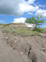
you know). We had a reasonably-filling meal at one of the few establishments open on a Sunday night, and then continued down the river towards our campground for the night in Rosedale. As we set up the tent, we could see flashes o lightning in the distance. The storm was also making its way down the river, and arrived in fine form sometime around midnight.

Stats:

Av. Spd.: 15.3km/h (I know, incredibly slow… the route was surprisingly hilly, and we did fight a headwind most of the day, not to mention the margarita effect mentioned above)

Mx. Spd.: 53.7km/h

Biggest actual disappointment: We didn’t stop in Wayne, Alberta, a ghost town that I had been looking forward to visiting. It would’ve involved a 15km detour on, we were told, gravel roads, so we decided to skip it. Luckily, we made it to East Coulee the next day, which is another ghost town.

Biggest surprise: Apparently, the Albertosaurus has been renamed “Gorgosaurus”. Who thought that was a good idea?

Hoodoo sightings: 2 tiny ones near the museum.

Funny stats to report: None today, I guess.


Wednesday, July 21, 2010

Special announcement

Before we post the rest of the latest blog updates, we feel compelled to mention that our good friend Alex is turning 30 today!! HAPPY BIRTHDAY ALEX!!! You may remember Alex from Day 1, as he accompanied us to Abbotsford. Alas, he was too old and feeble to continue this epic journey with us, but we wish him a happy birthday regardless.

Alex, being on our bikes in the Prairies and not in Vancouver with you to celebrate, we would like to give you the best gift from the road we could think of: our spandexed bodies spelling out the letters of your name set within the vivid colours of the Prairie landscape. Enjoy.

Day 15 – Calgary to Carbon (T.D.: 116km; S.T.: 5h46min)

Up early and feeling refreshed after a blissful rest day. We were on the road by 8:30am, and our first task was to climb up and around Nose Hill, the comically-named mound that sits in the north end of Calgary. From there it was east on Country Hills Boulevard (that’s a lot of hills already for a prairie city – maybe Calgary’s not considered a prairie city?!) for about 30km. We were thankful that it was early on a Saturday morning, as traffic wasn’t too thick yet – though it was certainly present (unlike the shoulders - haha, joking mom (not really joking – can Moms read the parantheses that are in parantheses? (I hope not))).

After these 30 kilometres were completed, we were alerted to our next turn off by a most informative sign (see photo). Having been alerted to the importance of this intersection, we consulted our directions, duly turned left, and continued north for another 30 kilometres into a small town called Beiseker. Along the way, we passed another small town called Irricana, where there was a sign that read “Giant Grasshoppers – This Way”. It is to my great disappointment and eternal regret that we did not follow this sign. What were we thinking? Anyway, there were no giant grasshoppers in Beiseker, again to my great disappointment.

There was a train car, however, in the shade of which we sat, had lunch and talked to some of the locals. Two young Beisekerites, Mackenzie and Stephanie told us a bit about the town, and then an older man – we’ll call him John the Baptist – told us a bit about everything else.

After an ice cream, we left our friends in Beiseker and continued along the long straight road to Carbon. Now, you might say that biking on long straight roads is easy, and I might not disagree with you, but at least one danger lurks on these prairie highways and it is not to be trifled with, let me assure you. It rears its head when you least expect it, when you have let your guard down, when your faith in the quality of the Alberta highway shoulders has allowed your eyes to wander to the tranquil scenery around you; then as you dreamily cruise past the golden canola fields, it strikes: Kablammo! And where should you find yourself but planted into the rear fender of your riding partner, who, moments before, had decided to stop and take a picture of said canola fields, and now, on the ground with limbs akimbo, is cursing you for your lack of attention.

Yes, my friends, somewhere outside of Beiseker, we had our first collision with each other. I say first, because not 2 hours later did we have our second. What magic is this? These prairies cast strange spells, I say.

Fortunately, no one was seriously injured either time, and our bikes seemed to withstand the impact quite remarkably. Better than our pride, even.

Thankfully, no one was around to witness it.


Somewhat more attentive and alert, we were able to carry on to the little town of Carbon, where my Aunt Cathy and Uncle Ken were waiting for us. They had driven down from Edmonton to camp with us for the night, and informed us that Cousins Mike and Louise, as well as Louise’s boyfriend Brian were on their way as well! Oh happy day! It was a real treat to have these folks all make the trek down, and made our experience in Carbon an extremely memorable one. As they were able to pack a few more luxury items into their cars than we could onto our bikes, we had a very comfortable and delicious evening, replete with plank salmon, three different types of salad, two kinds of bread, and even a bottle of Como Sur (not to mention the margaritas).

And what’s more, what’s more – we had s’mores! Around a campfire! It was awesome, with a capital H – Hawesome. Thank you thank you thank you Cathy and Ken for bringing and making dinner – what a treat!

Some yahoos in the site next to us even set off a round of fireworks in a nearby ballfield, which provided some most fitting punctuation to a wonderful, celebratory visit.

Stats:

Av. Spd.: 20.1km/h

Mx. Spd.: 45.7km/h

Deer spotted (regular deer, not spotted deer): 6

Number of sunscreen bottles destroyed by unfortunate construction zone mishaps: 1

Embarrassing collisions: 2

Cellphones lost: 1 (during the second collision)

Cellphones recovered: 1 (thanks to Brian’s help, who drove us back to the collision site – good thing we had stopped to take a picture, so the collision site was easy to find)

Margaritas consumed: What? Margaritas!? What a treat!

S’mores consumed: I LOVE S’MORES